
Don’t get us wrong — we loooove the outdoors and know you do, too. But sometimes there are places that get a little too much love. In the Vail area, one of those locales is Booth Lake Trail, which is popular for its stunning views of Booth Creek Falls. However, it’s prone to overcrowding, resulting in parking headaches and effects on the terrain. Fortunately, if you’re in Vail and looking for the nearest hiking trails with waterfalls or alpine lakes, we have you covered.

Cascades Worth the Climb: Vail Waterfall Hikes
Upper Piney Trail
Head north of Vail Village to start this 6-mile, out-and-back hike from Piney Lake. The Upper Piney Trail is considered moderate in difficulty and will take you into the Eagles Nest Wilderness, where aspen groves come alive with stunning orange colors in the fall. The lake itself reflects the surrounding Gore Range, and there are ample spots to stop and soak up the views on your way to the scenic Upper Piney River Falls.
Find the Piney Lake Trailhead: Drive north from Vail on Red Sandstone Road for about 12 miles to Piney Lake. Park near Piney River Ranch, where the trail begins along the lake’s shoreline.
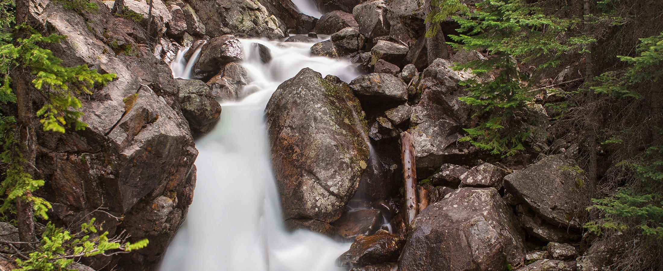
East Vail Falls Trail
You can see East Vail Falls from I-70, but if you want a closer look this is the way to do it. Though it’s about a mile out and back, it’s not for the faint of heart or novice hikers. This steep and difficult East Vail waterfall hike includes sections where you’ll have to use the provided ropes to reach your destination. Be sure to have proper footwear for good traction and avoid going when it’s slippery. Once you’ve made your way to the top, the cooling mist of the falls will greet you.
Find the East Vail Falls Trailhead: At I-70 Exit 180, take Bighorn Road into East Vail and turn right on Bridge Road to Lupine Drive. The trail begins nearby and climbs steeply to the falls.
Pitkin Creek/Lake Trail
With a creek, two sets of waterfalls and a lake, there’s no shortage of water on this moderate/hard hike in East Vail. To reach Pitkin Lake you’re looking at approximately 10 miles out and back, but there’s plenty to enjoy along the way — and the views are well worth the effort. The Pitkin Creek Trail starts a bit steep, but levels out after a mile or so. The beautiful Pitkin Falls come into view about 2.5 miles in, with another cascade a mile later. Pass through meadows that teem with wildflowers in July and August before you reach aquamarine waters surrounded by dramatic granite walls.
Find the Pitkin Trailhead: From I-70 Exit 180, take Bighorn Road then make a right on Fall Line Drive. Follow it to the Pitkin Creek Trailhead parking area.
Bighorn Trail
Explore this section of East Vail with a 7-mile round trip to an old mining cabin dating back to the early 1900s. Along the way you’ll pass beaver ponds, cross Bighorn Creek and can view the seasonal Bighorn Falls in the distance. Though it’s considered challenging, this trek affords the best view of the iconic Grand Traverse, a continuous ridge connecting a stretch of 12,000- and 13,000-foot peaks. The classic vista is seen from Vail Village looking east down Gore Creek Drive.
Find the Bighorn Trailhead: Take I-70 Exit 180 and follow Bighorn Road to Columbine Drive, which leads to the Bighorn Trailhead parking lot.
Scenic Rewards: Mountain Lake Hikes Near Vail
Lost Lake Trail
There are two trailheads for this route, but we recommend heading from the western point to make Lost Lake your destination. This provides an easy/moderate, out-and-back trek of about 7 miles. You’ll follow a ridge that winds through lodgepole pine and aspen groves, framing vistas of Mount of the Holy Cross and Vail Mountain in the distance. At the lake, settle in for a quiet picnic next to the placid waters.
Find the West Lost Lake Trailhead: Drive north from Vail on Red Sandstone Road for about 7 miles to the trailhead area.
Deluge Lake Trail
For a longer and more difficult option, this 9-mile out-and-back trail in East Vail rewards hikers with unbeatable views of Gore Creek Valley, the Sawatch Range and summertime blossoms. It’s ideal for birdwatching and traverses through boulder fields and a creek before you reach the splendor of Deluge Lake’s glassy surface.
Find the Deluge Lake Trailhead: From I-70 Exit 180, follow Bighorn Road all the way to the Gore Creek Trailhead. Start on the Gore Creek Trail and the Deluge Lake Trail splits off about 0.1 miles in.
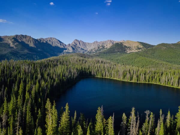
Gore Creek/Lake Trail
This hike combines two trails, Gore Creek and Gore Lake, for approximately 12 miles to the lake and back. It’s considered strenuous, and this excursion is popular for backpacking and camping. You’ll start on the Gore Creek Trail in East Vail, following Gore Creek for much of it and immersing yourself in the breathtaking scenery of the Eagles Nest Wilderness before a final ascent up to turquoise Gore Lake. If you go in the fall, you’ll be treated to an array of vibrant foliage. Mountain goats also frequent the area around the lake, so keep an eye out for them but maintain your distance.
Find the Gore Creek Trailhead: From I-70 Exit 180, follow Bighorn Road all the way to the Gore Creek Trailhead.
Grouse Lake Trail
Southwest of Vail near Minturn is where you’ll find this picturesque — yet difficult — trail that travels roughly 10 miles out and back. As you head toward Grouse Lake, the path crosses back and forth several times over bridges, logs and stones, providing an opportunity to cool off. Continue rising above the aspen, pine, spruce and fir trees until you arrive at the lake’s tranquil waters.
Find the Grouse Creek Trailhead: Take I-70 Exit 171 to US-24 east; follow to Haymeadow and make a right, where there’s a parking area.

Bonus: An Easy Hike Near Vail Village
Village Streamwalk Trail
You don’t even have to leave town for this easy out-and-back jaunt that clocks in around 1 mile. Start at the historic Gore Creek Covered Bridge and make your way east, following the north side of babbling Gore Creek, also known as Vail’s treasured waterway. As you pass through Vail Village, breathe in the scent of pine trees and keep an eye out for furry and feathered wildlife — the trail is popular with birdwatchers. Once you reach Ford Park you can enjoy Betty Ford Alpine Gardens, which features flowers and plants unique to Rocky Mountain ecosystems, sculptures and water features.

Tips for Hiking Around Vail
Enjoying the outdoors also comes with a responsibility to maintain these gorgeous spaces and ensure your safety. Here are some things to keep in mind before you hit the trail.
- Practice the Leave No Trace Seven Principles.
- Double-check that dogs are allowed on your trail of choice, keep your furry pal leashed and pack out any poo.
- Stay on designated trails and yield to hikers coming uphill.
- Watch out for wildlife and maintain a respectful distance; you should also be familiar with what to do if you encounter certain kinds of animals.
- Keep an eye on the weather. Conditions can change rapidly, and you should start your hike early enough in the day to avoid late-afternoon storms.
- Wear moisture-wicking clothing (especially socks) and appropriate footwear for the conditions.
- Avoid parking struggles at trailheads and take a free bus instead.