


Kinnickinnick Trail
Distance
1.4 miles (one way)Difficulty
BeginnerCrowds
HighBeginning Elevation
10,203 ft.Ending Elevation
10,954 ft.Elevation Gain
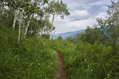
758 ft.From the top of Gondola One at Mid-Vail, towards the 10th Restaurant, there will be a a skinny path uphill to the Kinnickinnick Trailhead alongside Meadows Loop Trail.
The initial stretch winds uphill, intersecting several ski runs amidst blooming meadows. Despite occasional steep segments early on, the trail mellows out after crossing several small mountain streams. Venture into the forest for some shade and enjoy scrambling over scattered rock formations. The trail gradually gains elevation with gentle switchbacks, leading to a junction with the midpoint of the Sunlight Trail, marking the end of your journey.
Kinnickinnick Trail
Care for Colorado: Leave No Trace
Exploring Vail goes hand in hand with caring for our beautiful natural environment. Here’s how you can do your part!
Stay on the Trail
No shortcuts — going off trail compromises trail construction, kills the vegetation, increases soil erosion and may result in reduced water quality.
Pack Out Trash
Stash it until you can trash it — anything you bring with you, you must pack back out. Trash can hurt wildlife and contaminate water ways.
Dog Do's and Don'ts
Do pick up the doo — pack out all dog poop. Don’t let dogs off leash to protect them from wildlife and protect wildlife from them.
Respect Wildlife
Give them space — observe wildlife from a distance and do not follow or approach them. Never feed animals as it can alter their behavior.
Plan Ahead
Take the trail less traveled — there are more than 100 miles of hiking trails in the Vail area! Use the trail guide to discover area trails and, whenever possible, ride a bike or take a free Town of Vail bus to the trailhead.
Dogs & Leashes
Dogs are allowed in the White River National Forest, but may not be on permitted in certain areas of Vail Resorts. Please adhere to any posted signs. We recommend that you keep your dog on a leash when you are in Vail Resort and around other forest users, other dogs, or are in bear country.
Explore Other Hikes
Buffehr Creek Trail

Gore Valley Trail West (Lionshead Village to Dowd Junction)

Grand Escape Trail
Gore Creek Trail
Booth Lake Trail

Bighorn Creek Trail
Everkrisp Trail

North Trail (Red Sandstone to Son of Middle Creek)
