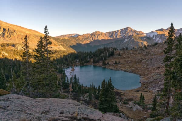
Please ensure Javascript is enabled for purposes of website accessibility
Skip to content
A silver gondola with a Vail logo on it heads up the mountain on a series of cables. Green trees and foliage blanket the terrain in the background.
A group of children walking in a grassy field near a ski lift.
A man and woman running on a trail.

Cabin Trail

Distance
2.3 miles (one way)
Difficulty
Advanced
Crowds
Light
Beginning Elevation
8,577 ft.
Ending Elevation
10,125 ft.
Elevation Gain
1,580 ft.

Cabin Trail is a moderately steep 2 mile single track trail, which crosses a few small streams along with groves of aspen trees and an abundance of wildflowers. The trail ends at the “Head First” ski run. From there, you can go downhill to the Main Vail dirt road or to get to Vail Village, go downhill to the east on Strawberry Lane.

Cabin Trail

Care for Colorado: Leave No Trace

Exploring Vail goes hand in hand with caring for our beautiful natural environment. Here’s how you can do your part!

Stay on the Trail

No shortcuts — going off trail compromises trail construction, kills the vegetation, increases soil erosion and may result in reduced water quality.

Pack Out Trash

Stash it until you can trash it — anything you bring with you, you must pack back out. Trash can hurt wildlife and contaminate water ways.

Dog Do's and Don'ts

Do pick up the doo — pack out all dog poop. Don’t let dogs off leash to protect them from wildlife and protect wildlife from them.

Respect Wildlife

Give them space — observe wildlife from a distance and do not follow or approach them. Never feed animals as it can alter their behavior.

Plan Ahead

Take the trail less traveled — there are more than 100 miles of hiking trails in the Vail area! Use the trail guide to discover area trails and, whenever possible, ride a bike or take a free Town of Vail bus to the trailhead.

Dogs & Leashes

Dogs are allowed in the White River National Forest, but may not be on permitted in certain areas of Vail Resorts. Please adhere to any posted signs. We recommend that you keep your dog on a leash when you are in Vail Resort and around other forest users, other dogs, or are in bear country.

Explore Other Hikes

hiking in piney lake

Lower Piney Trail

The Lower Piney Trail follows the Piney River downstream through meadows and aspen forests. At mile 1, the Wash Holland trail veers right. Stay left here. At mile 3.0, the... (Read more)
Grouse Lake trail sign image

Grouse Lake Trail

Grouse Lake trail begins on a logging road but turns to singletrack after 0.3 mile. At the signed junction with West Grouse Creek trail at 1 mile, keep left. The... (Read more)
Three women walking in a grassy meadow with mountains in the background in Vail, Colorado.

Ridge Route Trail

Finding this popular trail can be a bit tricky for first-timers. From the Eagles Nest gondola area head south towards signs for Game Creek. Shortly after, at a junction where... (Read more)
A family of four hikes amongst wildflowers with evergreens and mountains behind them in Vail.

Meadows Loop Trail

Meadows Loop Trail offers a scenic 2.5-mile journey through alpine meadows and forests. Purchase a Scenic Gondola Ticket and ride Gondola One from the Village up to Mid-Vail. The trailhead... (Read more)

Ptarmigan Loop

If you’re a fan of wildflowers and stunning vistas, Ptarmigan Loop trail is a must-visit. Starting from the end of Ridge Route and the peak of the Game Creek ski... (Read more)
group hiking

Shrine Ridge Trail

Shrine Ridge Trail begins at the trailhead located off I-70, leading hikers through lush alpine meadows adorned with vibrant wildflowers during the spring and summer months. As you ascend, you’ll... (Read more)
Family hiking through aspens

Strawberry Lane Trail

This alternative beginning of the Berry Picker Trail starts from the Vail Village Gondola One base. Ascend steeply through aspen groves, navigating small streams—some bridged, some not. Mind your step... (Read more)
Dirt trail among aspen trees and grasses with mountain views

Buffehr Creek Trail

CLOSED April 15 to June 20 From the Buffehr Creek trailhead, cross the bridge and proceed about 1/4 mile before turning right at the first junction (the trail to the... (Read more)
Buffehr Creek to Red Sandstone Gallery 1

North Trail (Buffehr Creek to Red Sandstone)

Closed April 15-June 20 From the Buffehr Creek trailhead, cross the bridge and proceed about 1/4 mile before turning right at the first junction (the trail to the left takes... (Read more)